Across the eastern seaboard of Australia, breakwaters and training walls have instigated fundamental perturbations to coastal and estuary processes. This has induced long-term changes to foreshore alignments, tidal currents, tidal planes and marine ecologies, with significant consequences. These effects can be seen right along the NSW coast of Australia, where breakwaters and training walls have been implemented.
The NSW coast
Coastal processes
River training works and dredging have been undertaken at the Tweed River in attempt to improve navigability. These works culminated in the extension of the training walls at the river entrance to form breakwaters. Although this improved navigation for a period, the entrance bar reformed and again created difficulties for navigation. The Tweed breakwaters have trapped sand, taking it out of the littoral system through the accretion of Letitia Spit, causing coastal erosion on the Gold Coast. This has resulted in the construction of expensive sand-bypassing systems and revetments to offset their impacts.
Mobile bed scale modelling has demonstrated conclusively that breakwaters can change beach alignments by creating artificial headlands, forming crenulated bays on what previously were linear shorelines.1 Where the scale of the breakwater is larger than the local wavelength, the perturbation will alter local wave transformation patterns thereby inducing a re-alignment of sandy foreshores.
The twin breakwaters constructed at the entrance to the Brunswick River effectively created a new headland. This resulted in significant accretion and re-alignment of the beach to the south, and erosion and formation of a crenulated shoreline to the north. The impact of the sand trapping to the south was so sufficient that within 10 years the small village of Sheltering Palms was devastated with cyclone waves breaking through the village into the North Arm of the Brunswick River. Natural by-passing was then established, and with the assistance of beach scraping, dunes and a beach were re-established to the north. However, the new alignment of the overall embayment still reflects the imposition of the artificial ‘headland’.
The northern breakwater at Nobbys Beach in Newcastle had the biggest impact on the shoreline at Stockton. This breakwater cut off the flood tide channel that had run along the beach and into the entrance. The result was the effective removal of the entrance bar and a significant accretion of sand on the northern side of the north breakwater. This accretion moved the shoreline approximately 300 metres seaward at the breakwater and resulted in a build-up estimated to be roughly two million cubic metres of beach sand at Stockton. It also induced erosion to the north as the shoreline responded to the changed tidal flow and wave conditions.
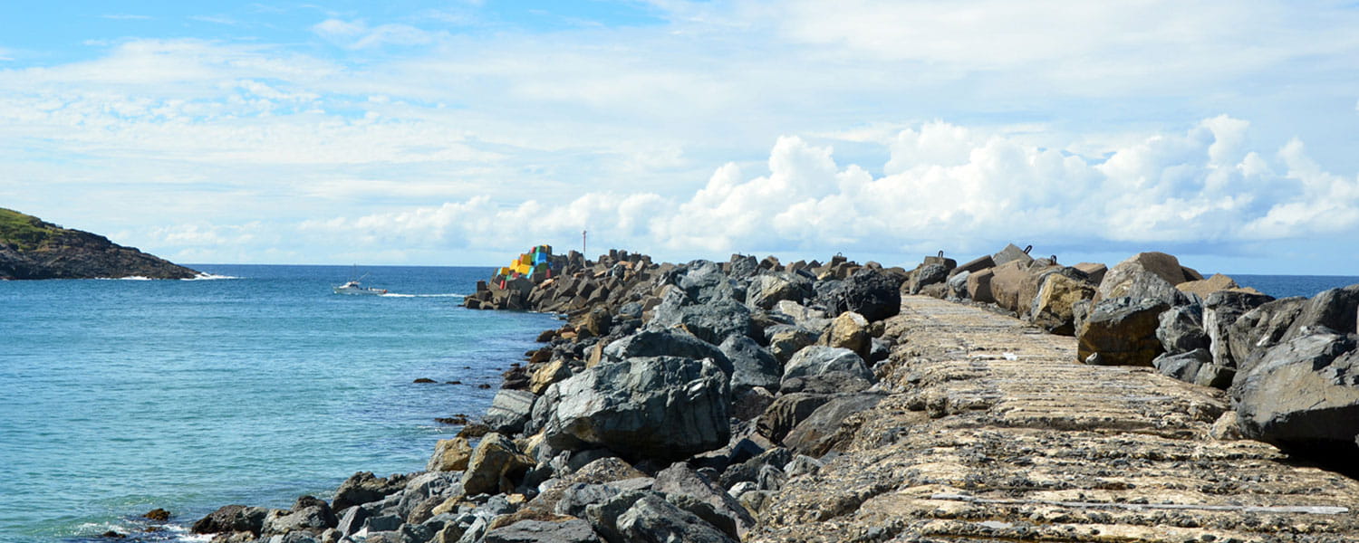
At Coffs Harbour a causeway was constructed to connect South Coffs Island to the mainland, providing protection for shipping visiting Coffs wharf. The causeway effectively cut the northerly drift of sand through the gap and onto the northern beaches, thus creating the new headland feature of South Coffs Island. Subsequently, northern and eastern breakwaters were constructed to provide further protection. Sand volume changes2 indicated that prior to the causeway construction the annual rate of littoral drift transport through the gap averaged 75,000 m3/a. After breakwater construction, Boambee Beach, to the south of the harbour, responded by building out at a rate of between 3 and 5 m/a. Over the past 100 years, between 5 and 6 million cubic meters of littoral drift were trapped south of the harbour with a further 1 million trapped inside the harbour. The harbour entrance has reduced in depth from 13 m to 6.5 m over the same period with significant shoaling throughout the harbour. Boambee Beach has realigned as a result of the accretion and the beaches to the north have experienced long-term recession.
Estuary processes
The construction of entrance breakwaters on Wallis Lake, Lake Macquarie, Lake Illawarra and Lake Wagonga has triggered unstable scouring modes at these estuary entrance channels. From 1990 to 2015 the spring tidal ranges in both Wallis Lake and Lake Macquarie have been increasing at a rate of 1.8 mm/a over lake areas of some 100 km2. That represents annual increases of some 400,000 m3 in the volume of water flowing into and out of the lakes each day on spring tides. At Lake Wagonga (Narooma) the spring tidal range has been increasing at a rate of 3 mm/a over an area of 7 km2, representing an annual increase of some 40,000 m3 in the volume of water flowing into and out of the lake each day on spring tides. At Lake Illawarra the rate of increase is some 8 mm/a. Ever-increasing channel velocities are causing channel scour and sand deposition in the lakes and the coastal littoral drift systems.
Training walls in tidal channels increase hydraulic conveyance and channel velocities.3 In 1987 a rock training wall was constructed on the northern bank of the Coffs Creek entrance. This changed an ICOLL (Intermittently Closed and Open Lakes and Lagoons) to a permanently open estuary. The deepened channel discharged spring ebb tides at speeds over 1 m/s and the creek bed portrayed current-related bedforms over 0.5 m high.4
On 23 January 1999, one enthusiast was sporting in the creek when his head hit a bedform as he dived into the fast-flowing turbid waters of unknown and variable depth, rendering him quadriplegic. After the trial, the Council erected four signs at access points: three on the northern bank of the creek and one on the southern side.